








ShareTweetWhatsAppPinShareEmail0 Share
Today, about a billion people live in deserts. This isn't a new trend. People have been walking the dunes since prehistoric times. However, most of us have no interest in moving to an oasis and trading our car for a camel. Life in the desert is hard.
But ancient cultures once mastered these arid landscapes in ways we are only beginning to understand. Archaeologists have discovered burial sites along ancient transport routes and the ruins of settlements that flourished for centuries. Desert dwellers of past centuries have also given humanity the oldest known architectural plans, rock shelters used by cultures separated by thousands of years, and a host of unusual mysteries.
This list features ten remarkable locations where surprisingly large finds are often discovered, suggesting that the desert was home to some of history's most innovative and enigmatic people.
See also: Top 10 Archaeological Restorations
10 Life-Size Artworks That Lead to the Water
Scientists have discovered life-size images of camels carved into rocks in the Arabian Desert.
Around 2023, researchers visited the desert in northern Arabia. They were looking for rock art and found several, but these weren't the usual depictions of humans hunting animals. Across 62 panels, they documented 176 engravings, including 130 life-size images of animals such as wild asses, camels, ibex, bison, and gazelles.
Some works were executed in extremely awkward locations. One panel is located 112–128 feet (34–39 m) above the ground and contains 23 life-size images of camels and horses. The artists could only work on a ledge approximately 12–20 inches (30–50 cm) wide.
To understand when and why these images were created, the team examined archaeological deposits beneath the carvings. One engraving tool was found in a layer dating back approximately 12,000 years. The researchers also discovered arrowheads and beads made of stone and dentalium shells. These shells must have traveled at least 199 miles (320 km) from the Mediterranean or Red Sea, while other artifacts indicate technological connections with Levantine communities.
But why climb the rock to create such enormous images? The engravings were located along routes connecting seasonal water sources. Researchers believe that the prominent animal images may have marked these routes and valuable water supplies, possibly also indicating territorial rights or access rights. In the desert, where the presence of water could mean the difference between life and death, a 12,000-year-old rock carving of a camel may have been far more useful than mere decoration.[1]
9 circular cemeteries in the Atbay Desert
New satellite discovery: 260 unknown monuments discovered in Africa.
In northeastern Africa, in a corner of the Sahara known as the Atbay Desert, there are hundreds of enormous circular burial structures, dating mostly to the fourth and third millennia BCE. Researchers have mapped 280 of them, located in a region stretching from Upper Egypt through Sudan to Eritrea.
These structures range in size from 16 to 269 feet (5–82 m) across. Rather than simple tombs, many are circular or oval structures containing burials and other features, sometimes with a prominent grave at the center.
Only a small number of such sites have been excavated, so archaeologists caution against assuming that all 280 sites contained identical burial types. One well-studied enclosure in Wadi Hashab was approximately 18 meters in diameter and contained over 25 human and animal burials. The central human burial was surrounded by burials of cattle, sheep, and one other individual.
This arrangement may indicate the existence of a certain social hierarchy, with particularly important individuals receiving prominent central burials. However, researchers are still unable to determine precisely who these individuals were and why they were accorded special treatment.
The monuments also survived remarkably long. Communities later reused them several thousand years after their original construction. Ultimately, increasing aridity as the African Humid Period ended may have disrupted the pastoral lifestyle that led to their construction.
Whatever their exact purpose, the Atbai cemeteries transformed vast tracts of barren desert into a monumental landscape of the dead.[2]
8 of the world's oldest drawings
Largest prehistoric man-made structures: kite-shaped animal traps found in the desert.
Millennia ago, Stone Age people knew how to harvest large quantities of meat in a single hunt. They built giant traps called desert kites, so named by archaeologists because their long stone walls and enclosures resemble kites when viewed from above. Herds of wild animals could be driven along the tapering walls into the trap area.
In 2023, researchers announced the discovery of something even more astonishing: ancient engravings depicting these massive structures with astonishing accuracy.
One of the carvings from Jordan is carved on a limestone slab approximately 80 cm long and dates back to approximately 9,000 years ago. Another, carved on sandstone in Saudi Arabia, measures approximately 3.82 by 2.35 meters and is approximately 8,000 years old.
When researchers compared the engravings with nearby desert kites, the similarities went far beyond artistic interpretation. The Saudi plans were drawn at approximately 1:175 scale, while the Jordanian example was drawn at approximately 1:425 scale. Their proportions and layout precisely matched the actual structures, which stretched for hundreds of meters across the landscape.
This makes them ancient architectural plans, drawn to scale. Researchers are unsure whether hunters literally used them as construction plans; they may also have helped groups plan and coordinate hunts or served some symbolic function. In any case, Stone Age people were transforming vast landscapes into precise two-dimensional diagrams thousands of years before anything comparable appears anywhere else in the archaeological record.[3]
7. 4th-century settlement in Egypt
NEWS | Lost Ancient Egyptian City Discovered!
In 2026, Egyptian authorities announced the discovery of a remarkably well-preserved fourth-century settlement at Ain el-Sabil in the Dakhla Oasis in Egypt's Western Desert. The discovery dates back to the late Roman and early Christian periods of Egypt, when Christianity was gaining increasing importance in the Roman Empire.
This was more than just a tiny roadside town in the desert. Archaeologists discovered planned streets and squares, defensive towers, a basilica, and mud-brick houses with vaulted roofs. Inside were reception rooms, kitchens, bread ovens, granaries, and common household items.
Nearly 200 ceramic fragments with inscriptions in Greek and Coptic provided an unusually intimate glimpse into the lives of local residents. The texts recorded trade transactions, correspondence, and other details of everyday life that rarely survive for more than 1,600 years.
One of the houses is even associated with a deacon named Tisu. Archaeologists believe that Christian meetings may have been held there even before the construction of the basilica in the settlement, indicating the development of religious life in the community.
Much more than just walls remains in the desert. Among the ovens, handwritten messages, streets, houses, and meeting places of early Christians, Ain el-Sabil offers something of a snapshot of ordinary life in a changing Roman Egypt.[4]
6. A desert kingdom fed by ancient underground waters.
The Garamantes dug underground tunnels across the Sahara – and then the empire disappeared.
The Sahara Desert is renowned for its hot and arid landscape. However, one society was undeterred by this inhospitable terrain. Indeed, the Garamantes founded a thriving civilization in what is now southwestern Libya between approximately 400 BCE and 400 CE, without relying on a permanent river for their water supply.
For a long time, outsiders considered the Garamantes to be nothing more than desert nomads. However, archaeological research has revealed a completely different picture. Their capital, Garama, may have housed around 4,000 people, and their settlements and territory extended over approximately 70,000 square miles (180,000 sq km).
Their success depended on an ingenious irrigation system known as foggara. Instead of waiting for rain, workers dug horizontal tunnels into sandstone aquifers containing ancient groundwater. Vertical shafts allowed workers to excavate and maintain the tunnels, while gravity-fed water flowed to farms and settlements.
Archaeologists have uncovered a total of about 750 km (466 mi) of these underground tunnels and shafts, with most of the construction taking place between approximately 100 BC and AD 100. Some individual tunnels extended for several miles.
The system worked remarkably well, but it relied on groundwater, which was practically never replenished by modern sources. Over time, falling water levels led to a decline in the productivity of many foggaras, making their expansion increasingly difficult. Researchers believe that the growing water shortage was a significant factor in the subsequent decline of Garamantian society.
Their true achievement, perhaps, is that the system worked for so long. The Garamantes built an urban civilization in one of the driest places on Earth, using water that had accumulated beneath the Sahara long before their kingdom existed.[5]
5 roads of graves
Al-Ula Revealed: Saudi Arabia's Archaeological Masterpiece.
Around 4,500 years ago, nomadic herding communities traversed the deserts of northwestern Arabia, moving between oases, pastures, and permanent water sources. Their routes became so densely dotted with tombs that archaeologists now call them "burial alleys.".
Researchers studying the regions around Al-Ula and Khaybar have discovered more than 17,800 pendant tombs, approximately 11,000 of which are associated with these ancient routes. The network of routes discovered extends for approximately 329 miles (530 km).
Some sections are strikingly crowded. Archaeologists have discovered sections where there were up to 22 funerary monuments per 100 meters (328 feet) of path. From above, the tombs often resemble round stone heads with long tails extending behind them, creating a distinctive pendent form.
Burials weren't necessarily designed as road markers, but their close association with transportation routes suggests that movement across the landscape and the care of the dead were closely intertwined. Travelers heading between reliable water sources passed grave after grave, sometimes for many kilometers.
In an area with few permanent landmarks, the routes between settlements became dotted with monuments to the people who had traveled them before.[6]
4. Petra's sister city
Inside Hegra, the Lost City of the Nabataeans | SLICE HISTORY | FULL DOCUMENTARY
Petra is famous for its monumental structures carved directly into the pink rock face, but the Nabataeans created another extraordinary center in the desert hundreds of kilometers away. Hegra, also known as Mada'in Saleh, flourished in what is now northwestern Saudi Arabia and served as an important point on the trade routes linking Arabia with the Mediterranean.
Like Petra, Hegra is best known for its intricate sandstone facades. More than 100 monumental tombs remain, many of which are adorned with architectural elements reflecting a remarkable blend of Nabataean, Egyptian, Greek, Roman, Persian, and Mesopotamian influences.
One of the most impressive is Qasr al-Farid, or "Lonely Castle." This unfinished tomb rises approximately 72 feet (22 m) above a solitary sandstone outcrop. Its upper façade is intricately carved, while beneath it, crude chisel marks are visible, precisely indicating where the builders left off.
Thousands of surviving Nabataean inscriptions contain names, professions, legal warnings, and clues about the society that created Hegra. The Nabataeans left behind no extensive written history describing their civilization in their own words, so archaeologists must reconstruct much of their world from tombs, inscriptions, trade routes, and architecture.
In 106 CE, Rome annexed the Nabataean kingdom, and Hegra gradually declined as trade routes shifted. But its desert isolation preserved one of the most impressive surviving examples of Nabataean architecture outside Petra.
Petra may be seen on postcards, but its Saudi Arabian counterpart has quietly guarded more than 100 monumental tombs in the desert for centuries.[7]
Rock paintings created 3,000 years ago
Umm Arak Plateau: Discovering 10,000 Years of Rock Art in Sinai.
In South Sinai, Egypt, archaeologists recently discovered a sandstone shelter on the Umm Arak plateau, extending for more than 100 meters (328 feet). Its walls contain rock paintings and inscriptions created by people who returned to the site over the millennia.
The oldest images painted in red paint are believed to date from 10,000 to 5,500 BC. These include images of people and animals, created at a time when the landscape and the lives of its inhabitants were very different from those encountered by later desert travelers.
Much later visitors left their own traces. Researchers discovered Nabataean inscriptions and Arabic script dating to the Islamic period, indicating the repeated use of this shelter by various cultures over a vast period of time.
Excavations beneath the rock art sites have revealed evidence that people did more than just carve and draw. Archaeologists have discovered thick layers of animal dung, hearths, stone tool blocks, flint tools, and pottery, suggesting that travelers frequently sheltered here with their livestock.
Thus, this site preserves more than just a gallery of changing artistic styles. It records generations of people who used the same protected area of desert for rest, shelter, communication, and possibly rituals.
Some visitors to Umm Arak had met over the course of thousands of years, but they all seemed to agree on one thing: if you find a good place to camp in Sinai, leave something on the wall.[8]
2. Prehistoric hotel in a lava tube.
«Discovery of Ancient Life in Saudi Arabia's Umm Jirsan Lava Tubes | Neolithic Shepherds and Rock Art»
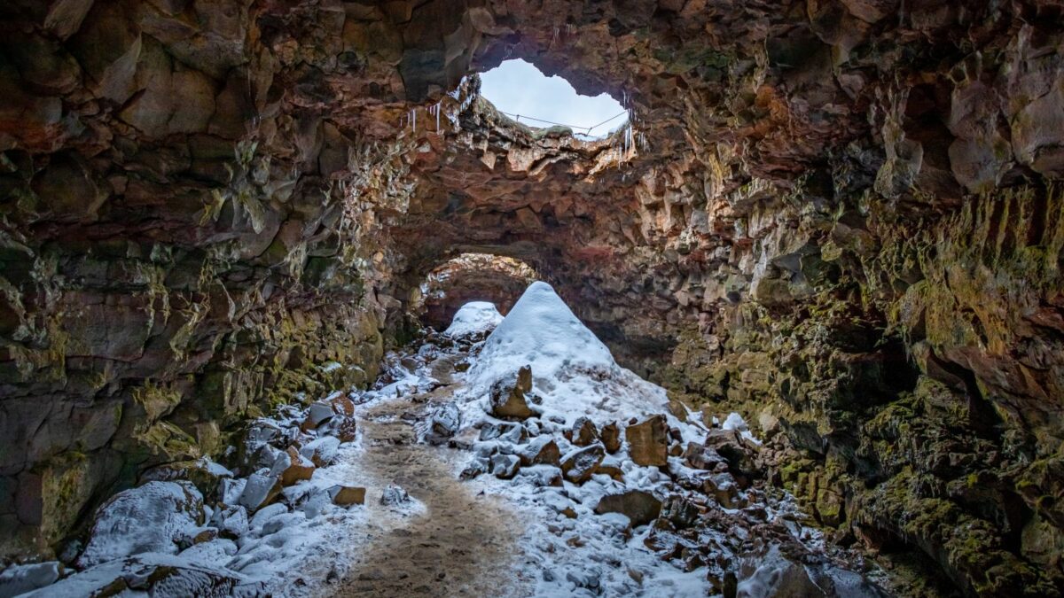
Northern Arabia contains vast lava fields formed by ancient volcanic eruptions. When the surface of a lava flow cools and hardens, and molten lava continues to flow beneath it, the remaining lava can eventually flow away, leaving behind a hollow tunnel.
One such tunnel, Umm Jirsan in Saudi Arabia, has become a surprisingly convenient refuge for people and animals.
Archaeological evidence suggests that the lava tube has been used repeatedly by humans for at least 7,000 years, and possibly as long as 10,000. Pastoralists likely used it temporarily rather than permanently, during their travels between oases and pastures.
Excavations uncovered stone tools, pottery, animal remains, and human bones. Isotope analysis of the human remains revealed that the diet was rich in animal protein, while plant consumption increased over time as agriculture and oasis settlements developed in the region.
Nearby rock paintings confirm the pastoral theme, depicting cows, sheep, goats, and people herding livestock. These paintings were discovered as a result of a lava tube collapse approximately 1.3 km from the excavated Umm Jirsan passage, not inside the cave itself.
The lava tubes also attracted undesirable inhabitants. In another part of Umm Jirsan, huge deposits of bones collected by striped hyenas were discovered, including animal remains and fragments of human skulls, apparently found in burial sites.
For thousands of years, people used the tunnel as a convenient stopover in the desert. Hyenas apparently also enjoyed such shelter.[9]
1. Temple of the Clay God
An Egyptian god named Mud had a temple full of water | Incredible Facts
In the ancient city of Pelusium on Egypt's Sinai Peninsula, archaeologists spent years excavating what was initially thought to be a civil or administrative building. What emerged from the sand turned out to be much stranger: a sanctuary centered on water, Nile silt, and a local deity associated with mud.
The structure was a circular pool approximately 115 feet (35 m) in diameter, connected by canals to the ancient Pelusian branch of the Nile. Archaeologists believe the silt-rich water of the Nile played an important role in the rituals held there.
The sanctuary was apparently dedicated to Pelusium, a local deity whose name is related to the Greek word pelos , meaning "mud." The pedestal in the center of the pool may have once supported a monumental statue of a god, and a hydraulic system allowed water and sediment to flow into the sacred space.
Researchers have long resisted attempts to accurately recreate the rituals, but engineering solutions clearly demonstrate one thing: the dirt wasn't an unfortunate side effect. It was part of the religious experience.
The sanctuary appears to have been in use from approximately the 2nd century BC to the 6th century AD. Its architecture and artifacts combine Egyptian, Hellenistic, and Roman influences, reflecting Pelusium's position as a cultural and commercial crossroads between Egypt and the Mediterranean.
The ancient Egyptians worshiped gods represented by falcons, crocodiles, jackals, and cats. At Pelusium, worshipers apparently found something sacred in objects most people would avoid lugging around their homes for the rest of their lives.[10]
More great lists
 10 Amazing Stories of People Who Escaped the Rat Race
 10 Amazing Things We've Recently Learned About Animals
 10 Amazing Facts About Roxelana's Remarkable Life
 10 Amazing Ways Wild Animals Show Respect and Affection
 10 Picturesque Burial Sites with Stunning Views
 10 Historical Places Every Traveler Should Visit
 10 Mysterious Military Sites in America
 10 Unexpected Ways Modern Tourists Have Caused Harm…
 Ten Totally Crazy Facts About the Sahara Desert
Fact checked by Darci Heikkinen ShareTweetWhatsAppPinShareEmail0 Share Jana Louise Smith
Yana makes her living as a freelance writer and author. She has written one book on a dare and hundreds of articles. Yana loves uncovering unusual facts about science, nature, and the human mind.
Read more: Facebook Smashwords HubPages